What NOAA’s 2026-27 winter outlook means for Mid-Atlantic skiers
NOAA’s winter outlook tilts the odds toward a warmer winter in Virginia, West Virginia, Maryland and Pennsylvania, and a wetter one across much of the region. For our slopes, that makes the snowmakers the story.
Vermont has already fired up the snow guns. Killington Resort said temperatures dipped below freezing early Saturday, Oct. 17, and its crews turned on 165 snow guns across five trails, “a full two weeks ahead of last year’s first snowmaking run.”
That is New England. Closer to home, the bigger news came two days earlier, when NOAA released its U.S. Winter Outlook on Oct. 15. Here is what it says for the Mid-Atlantic, and what it does not say.
Odds, not a forecast
Start with the most important point. NOAA’s seasonal outlook is a set of odds. It is not a snow forecast, and it does not promise anything for a given week or a given resort.
NOAA says so itself: “The outlook does not project seasonal snowfall accumulations as snow forecasts are generally not predictable more than a week in advance.”
What the outlook does give is the likelihood that a season’s average temperature and total precipitation land above, near or below normal. That is useful for planning. It is not a snow total, and anyone quoting one for this winter is not quoting NOAA.
What NOAA says for our region
The driver this year is El Niño. In its Oct. 15 long-lead outlook discussion, NOAA’s Climate Prediction Center wrote that “the seasonal outlooks for the upcoming winter and spring are heavily influenced by this very strong event.” The same discussion says CPC’s official ENSO outlook forecasts “high probabilities (80%) for at least a strong El Nino event to continue through the Jan-Feb-Mar (JFM) 2027 season.”
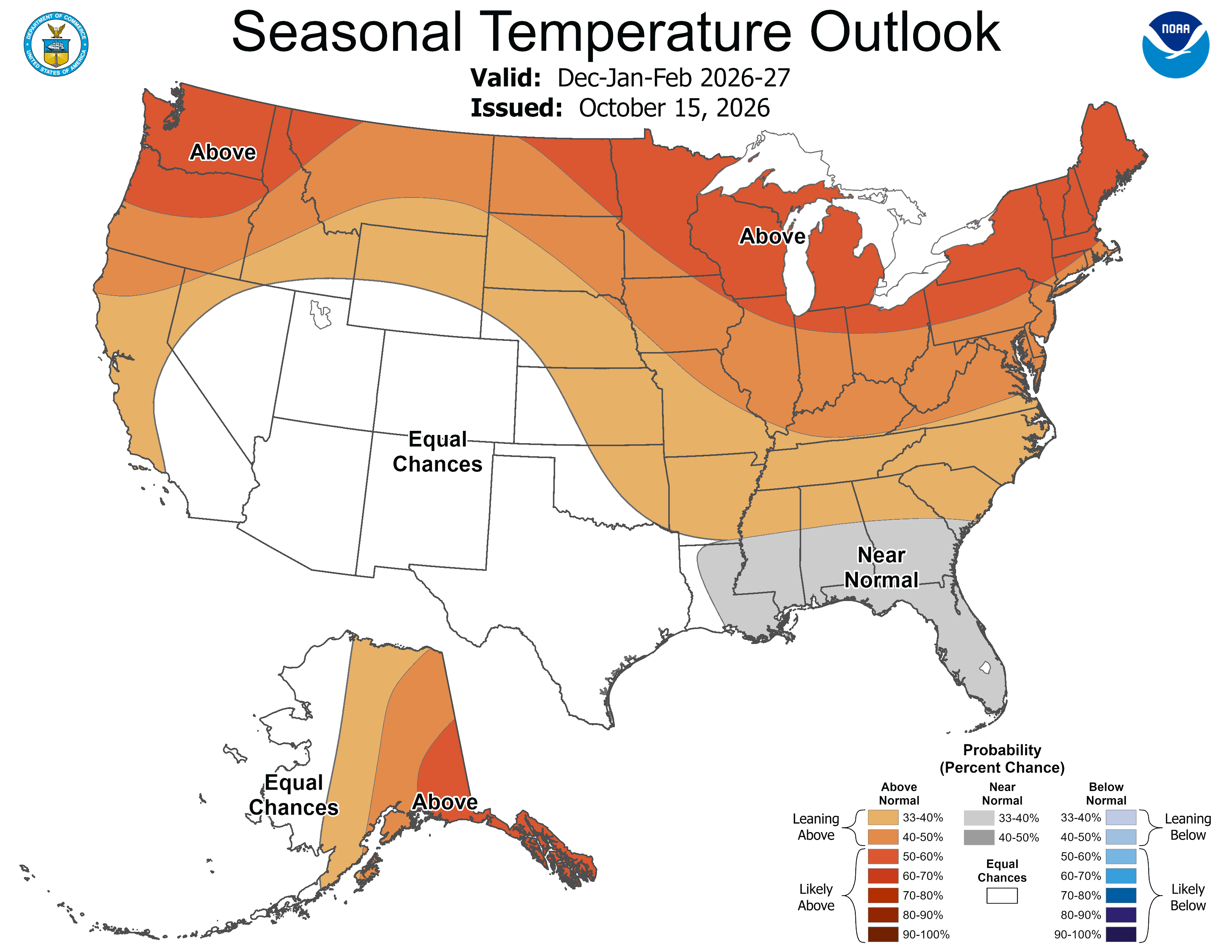
On temperature, the Climate Prediction Center wrote that its November through January outlook “favors above-normal seasonal mean temperatures” for several regions, including “the Ohio Valley and mid-Atlantic regions.” NOAA’s December through February map, above, shades all four of our states toward above normal, with the strongest odds, in the band NOAA’s legend calls “Likely Above,” across northern and central Pennsylvania.
On precipitation, the center’s November through January outlook found “an elevated likelihood of above-normal seasonal precipitation amounts” for a list of regions that ends “along the eastern seaboard.” On NOAA’s December through February precipitation map, those wetter odds are strongest toward the coast and fade heading west, with much of western Pennsylvania and western West Virginia left at equal chances.
Put plainly: for the heart of ski season, NOAA leans our region warmer than normal and, east of the mountains especially, wetter than normal. Leaning is the right word. These are tilted odds, not a sure thing.
Wet does not mean snow here
Extra precipitation does not automatically mean extra snow. In a mild Mid-Atlantic winter, it can fall as rain, sleet or a mix, and NOAA’s outlook makes no call on which.
That is why the warm odds matter more to local skiers than the wet ones. Our resorts lean on snowmaking, and snow guns need below-freezing air. If a warmer-than-normal winter comes, the question for each mountain is how much snow its crews can make when cold windows open, and how fast.
Several of our resorts spent the off-season on exactly that. We covered Wintergreen’s 14 new fan guns and new substation and Wisp’s snowmaking upgrades. In a winter that leans warm, that kind of work helps keep trails open.
What it means for opening day
When do Mid-Atlantic ski resorts open in 2026? The outlook cannot answer that, and neither can we yet. Opening days here follow the first good run of cold nights, not a seasonal map.
Snowshoe has posted its target: Wednesday, Nov. 25, weather permitting. We covered it in Snowshoe opening day, and the rest of the mountain’s season is in our Snowshoe 2026-27 events list. Other openings go on our opening-day calendar as resorts announce them.
A graduate study of NOAA records near our resorts found fewer hours cold enough for snowmaking at most sites since the mid-2000s.
For skiers, the practical takeaways are simple. Watch the short-range forecast for the first cold snaps, since that is when the guns come on. And if you have not settled your season yet, our 2026-27 ski pass guide lays out the options, and the Mid-Atlantic ski resort map shows who is within a drive.
Next update
This outlook is not the last word. The Climate Prediction Center says the current set “will be superseded by the issuance of the new set next month on Nov 19 2026.” We will check it against this one when it arrives.
Corrections: info@mtninfo.com